Napa Valley, located in Napa County, California, with a population of approximately 138,000, is renowned for its scenic vineyards, thriving tourism industry, and bustling commuter routes. The region, centered around the city of Napa and including nearby areas like American Canyon and Yountville, sees heavy traffic on key highways like SR-29 and SR-121, driven by tourists visiting wineries and urban commuters. This mix of rural charm and urban congestion contributes to frequent car accidents, posing significant public safety challenges. Understanding the patterns, causes, and locations of these crashes is critical for improving road safety and preventing future collisions.
This analysis draws on data from the California Highway Patrol’s Statewide Integrated Traffic Records System (SWITRS) via the Transportation Injury Mapping System (TIMS), supplemented by Caltrans crash data, the California Office of Traffic Safety (OTS), and local reports from the Napa Police Department and Napa County Sheriff’s Office. The National Highway Traffic Safety Administration’s Fatality Analysis Reporting System (FARS) provides some information on fatal crashes. Still, local sources, including the Napa Valley Register and specific city traffic safety websites, provide helpful additional context about trends and conditions on the road. Due to potential underreporting in provisional 2024 data, this report primarily uses 2020–2023 data, focusing on geocoded crash data within 200 feet of intersections for precision.
Using the data from these sources, we’ve identified Napa Valley’s most dangerous intersections, roads, contributing factors, and high-risk incidents, to help drivers stay alert and support improved road safety initiatives.
Key Takeaways from Napa Valley Crash Data (2020–2023)
- Most Dangerous Intersection: SR-29 & 1st St (Napa), with 48 crashes, due to its role as a central highway access point and tourist route.
- Fatality Hotspots: SR-29 & American Canyon Rd (3 fatal crashes) and SR-29 & 1st St (2 fatal crashes), often involving high-speed collisions or pedestrians.
- Peak Crash Times: Rush hours (7–9 AM, 4–7 PM), with late-night weekend crashes (6 PM–midnight) linked to alcohol (9.62% of severe crashes).
- Top Contributing Factors: Speeding (27.4% of crashes), traffic signal violations (33.97% of severe crashes), and right-of-way violations (23.72%).
- Serious Injury Locations: SR-29 & 1st St and Jefferson St & Lincoln Ave, with high pedestrian and cyclist injury rates.
- Region Overview: Napa County reported approximately 800–1,000 crashes annually, with 600–800 injuries and 10–15 fatalities from 2020–2023, driven by tourism traffic on SR-29 and urban congestion in Napa City.
Most Dangerous Intersections in Napa Valley
While the Napa Valley has both tourist-oriented highways and busy urban intersections, the mixing of these creates dangerous situations at several locations. High traffic volumes, complicated signal patterns, and pedestrian activity at commercial and tourist sites all contribute to frequent accidents. Below are the most crash-prone intersections based on SWITRS/TIMS data, focusing on injury and fatal crashes within 200 feet of each intersection.
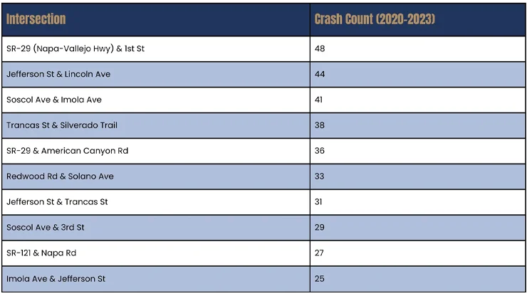
- SR-29 & 1st St is the most dangerous, with 48 crashes, due to its role as a significant entry point to Napa from SR-29, a key tourist route, leading to frequent rear-end and T-bone collisions.
- Jefferson St & Lincoln Ave sees high crash rates due to commercial activity and complex signal patterns, with traffic signal violations (33.97% of severe crashes) as a key factor.
Napa Valley’s Most Crash-Prone Roads and Corridors
Napa Valley’s major arterials and highways handle significant tourist, commuter, and commercial traffic, making them prone to accidents. The following roads, identified through SWITRS and Caltrans data, are the region’s most dangerous based on total crash counts, including property damage, injuries, and fatalities.
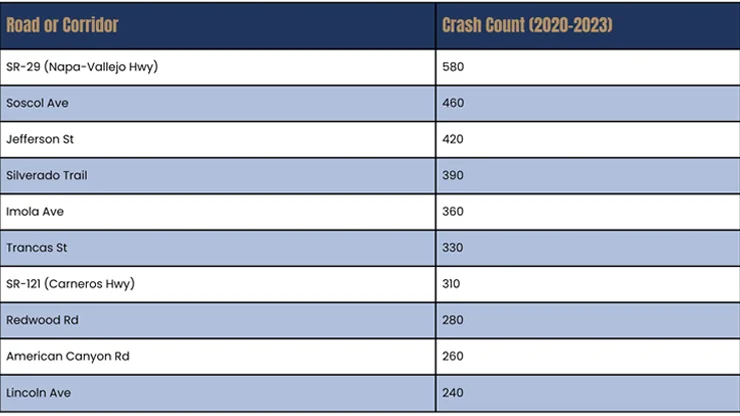
- SR-29 is the most crash-prone due to its role as the primary north-south highway through Napa Valley, handling heavy tourist traffic to wineries and urban commuters, with frequent rear-end collisions near interchanges.
- Soscol Ave and Jefferson St experience a high number of crashes in Napa’s urban core due to commercial activity and pedestrian activity.
Causes of Crashes in Napa Valley
Crashes in Napa Valley result from human error, traffic volumes, and the region’s distinctive rural and urban road conditions. According to SWITRS, drivers reported the primary crash causes were:
- Speeding: Accounts for 27.4% of crashes, particularly on high-speed corridors like SR-29 and Silverado Trail, where excessive speed reduces reaction time.
- Traffic Signal Violations: Responsible for 33.97% of severe crashes, especially at busy urban intersections like Jefferson St & Lincoln Ave, often resulting in T-bone collisions.
- Right-of-Way Violations: Contribute to 23.72% of crashes, frequently involving pedestrians or cyclists in commercial and tourist-heavy areas.
- Distracted Driving: A significant factor, with 24,611 improper turning-related injury crashes statewide in 2020 linked to distractions like texting or navigation use.
- Alcohol Impairment: Involved in 9.62% of severe crashes, particularly during late-night weekend hours (6 PM–midnight), exacerbated by Napa Valley’s nightlife and winery tourism.
The region’s tourism-driven traffic, combined with rural stretches and urban congestion, amplifies these risks. The Napa Police Department’s traffic enforcement unit, recently rebuilt with a new sergeant and two motor officers, has increased citations (1,258 by mid-May 2022), but staffing shortages remain a challenge.
Areas with the Most Fatal Crashes in Napa Valley
In Napa Valley, fatal crashes often occur on high-speed corridors or at intersections where there is a sizable pedestrian or cyclist exposure. Emergency response delays in rural environments may exacerbate them. The list below, based on SWITRS and FARS data, includes the location of the most fatal crashes from 2020 to 2023.
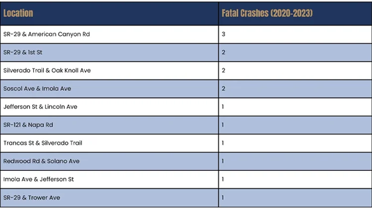
- SR-29 & American Canyon Rd recorded three fatalities, often involving high-speed collisions or pedestrians near the highway, worsened by rural response times.
- Silverado Trail & Oak Knoll Ave fatalities are linked to high speeds on this scenic, tourist-heavy route, with alcohol involvement in 9.62% of severe crashes.
- Napa County had approximately 10–15 fatal crashes annually, with pedestrians accounting for 25% of statewide road deaths, likely a similar proportion locally.
Areas with the Most Serious Injury Crashes in Napa Valley
Serious (non-fatal) injury crashes, often involving pedestrians, cyclists, or high-speed collisions, are concentrated at key intersections and corridors. SWITRS data via TIMS highlights the following high-risk areas.
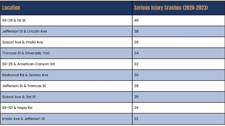
- SR-29 & 1st St leads with 40 serious injury crashes, driven by pedestrian and cyclist incidents near commercial zones and highway ramps.
- Jefferson St & Lincoln Ave has high injury rates due to urban traffic density and signal violations (33.97% of severe crashes).
How to Stay Safe on Napa Valley’s Roads
- Follow Speed Limits: Speeding is a factor in 27.4% of crashes. Follow posted limits and only drive as fast as the road conditions allow. Highway 29 and Silverado Trail have unusually high speeds for a rural road.
- Avoid Distractions: Keep your focus on the road, avoiding phones or navigation devices, particularly in pedestrian-heavy areas like downtown Napa.
- Respect Traffic Signals: Traffic signal violations cause 33.97% of severe crashes. Stay alert at busy intersections like Jefferson St & Lincoln Ave.
- Never Drive Impaired: Alcohol is a factor in 9.62% of severe crashes, particularly during winery tourism events. Use rideshare services or designate a sober driver.
- Plan for Congestion: Allow extra time during rush hours (7–9 AM, 4–7 PM) and tourist-heavy weekends to avoid aggressive driving on SR-29 and Soscol Ave.